

Las Torres de la Huerta is a network of stone towers scattered seemingly at random across the landscape just a few kilometres to the north of Alicante city. They were put there in the 16th and 17th centuries. Clearly this was a massive project in its day. But who built them, and why?
For the answer, let’s rewind to the 1500s. Working on the land around Alicante was kind of risky back then. Bands of marauding Berber corsarios from north Africa attacked the coastal settlements at regular intervals, intent on kidnap, pillage and worse.


Dangerous times!
If you couldn’t run away fast enough, being captured and sold as a slave in the markets of Algiers was a frighteningly real possibility.
One account talks of an attack on the coast in 1550 by 27 ‘Turkish’ vessels. Thirteen farm workers didn’t make it to safety in time and were kidnapped.
Another attack took place almost a century later, in 1643. This time, the settlement of San Juan was the target. The raiders looted the church and made off with 108 women, 42 children and 83 ancianos (elderly people). For a list of attacks – and there were a lot – tap here. It’s in Spanish, but Google Translate gives you a fair idea.

Who were the corsarios?
Known in English as the Barbary Corsairs, they were effectively legal pirates. Legal because they carried ‘letters of marque’ issued by the Beys (sub-kings) of Tripoli, Tunis and Algiers, authorising them to attack Spanish ships and the coastline. In return, the corsarios were expected to pay taxes on their loot when they got home.
Many European monarchs licensed their own corsairs in the 16th and 17th centuries, mostly as a good way of getting a navy on the cheap. The English gave their corsairs the more respectable name of ‘privateers’; Sir Francis Drake was the most famous example. The Spanish still call him a pirate though!
The Barbary Corsairs were feared all over Europe, even raiding as far north as Iceland. According to this article, an estimated 850,000 people across Europe were captured over the century from 1580 to 1680.
The corsarios even set up a base on Lundy Island, slap in the middle of the Bristol Channel. They often ransomed their captives – perhaps the best known was Cervantes, author of Don Quixote, who spent five years as a captive in Algiers until a ransom was paid. More about the corsairs here.

One answer to the corsair threat was towers. Lots of them. Places to run to when the piratas berberiscos were on the rampage. The strategy clearly worked, as the raids became much less frequent in the second half of the 17th century. And plenty of las Torres de la Huerta survive to this day.
What was la Huerta de Alicante?
The ‘huerta de Alicante’ is loosely translated as the garden of Alicante. But why was it worth protecting?
Four hundred years ago, it was rich and fertile farmland, largely thanks to the recently-built Tibi Dam up in the mountains, which released huge quantities of river water for irrigation.
But none of this extra cultivation was much good if the workforce lived in constant fear of attack.
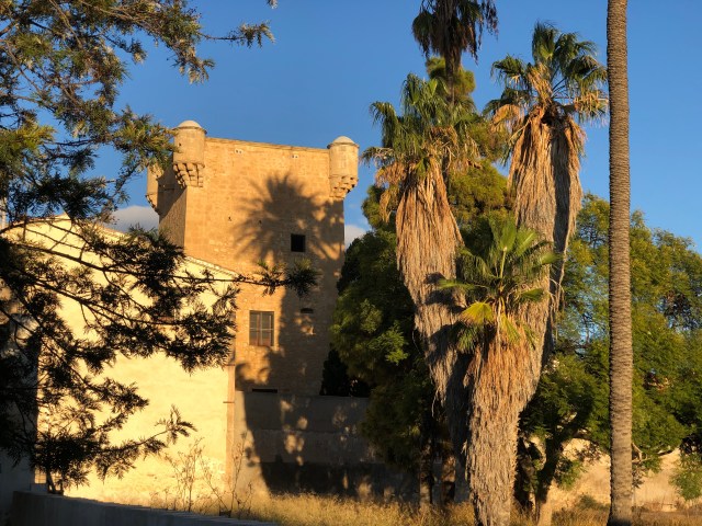
So over a 200 year period, around 30 towers were built. Some had houses attached where the landowner and his family lived, but they also doubled up as a place of refuge for the peasants who worked the surrounding land.

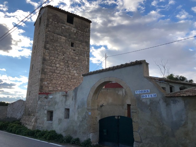
Some of the surviving towers are recently restored, plenty are private houses, one or two are restaurants, and more than a few look in serious need of some TLC.
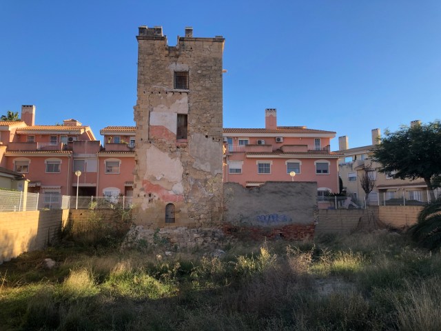
You’ll find some marooned incongruously in a sea of modern houses, flats and shopping centres, generated by the tourism of Playa San Juan and Albufereta. Frankly, there’s not a lot of agriculture going on in the huerta de Alicante these days.
On the tower trail
It’s fun tracking them down – try doing it on a bicycle or an e-bike. There are around 20 surviving towers scattered across San Juan and Albufereta. I reckon doing the lot on a bike would take you 2-3 hours. The trail is about 12km long in total.
There are a couple of maps at the bottom of this post – jump to them here. They’re based on this guide, which we followed. It’s in Spanish, but the visuals are very clear, even if you aren’t a Spanish speaker.


You can walk easily between some of the towers too, although doing all of them on foot in one day might be hard work in the heat of summer!
Each tower has a plaque nearby explaining its history (in Spanish and Valenciano only). The plaque also helpfully tells you where the next tower on the trail is.

The hidden towers
You can see nearly all of the 20 towers on the guide. Just a few exceptions: Tower 12 (Torre Alameda) is part of a private estate and can’t be seen from the road. To see what it looks like, check out this post instead. Tower 14 (Torre Bosch) is an events place and you can’t see it from the road either – but check this link for a virtual tour.
Finally – and disappointingly – the last one (Torre Tres Olivos) is just a heap of rubble at the back of a housing estate. Not worth the detour!


To view the last five towers on our route, just click or tap on the images below.


Suggested tower route
This map will take you round the first ten towers up to Torre de la Santa Faz, assuming you’re travelling by bike (Google Maps only lets you put 10 locations on any map!) The rest of the towers, from Torre de la Santa Faz onwards, are on the second map below.

More places to visit around Alicante
Check out these posts:
- Explore the castles of Alicante – La Ruta de los Castillos
- My top ten things to do in Alicante
- The spectacular skywalk at the Santa Pola lighthouse
- Take a trip to Tabarca, Alicante’s island
- The majestic Tibi Dam, source of irrigation water forla Huerta de Alicante
- Walk to the Cabo de la Huerta lighthouse
© Guy Pelham